Introduction
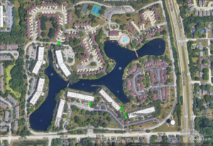
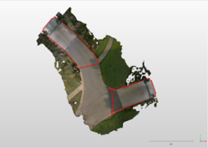
Site map of the property showing the locations of the 4 driveway areas that were scan and analyzed for drainage
For property managers overseeing multi-story, multi-unit condominiums, effective stormwater drainage is a vital concern. With evolving technology, LiDAR (Light Detection and Ranging) presents a groundbreaking approach to precision drainage calculations. Let’s delve into the insights from a recent LiDAR inspection of four driveways in a NW condominium complex.
Why LiDAR?
Traditional methods, like tripod-based terrestrial scans, have limitations. They capture data from a single vantage point, often missing out details due to obstructions like trees, shrubs, and elevation changes. LiDAR, especially mobile scanners like the Leica BLK2Go, revolutionizes this by capturing comprehensive 3D point clouds during a walk, ensuring no detail is missed. This aids in calculating accurate drainage topologies, determining areas that collect stormwater, and ensuring compliance with international plumbing codes.
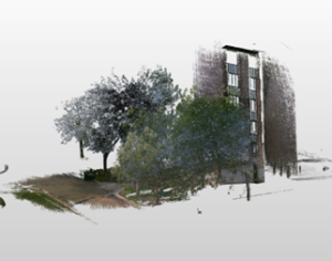
Point cloud capture of the 701 Lake Hinsdale driveway on the north face of the building.
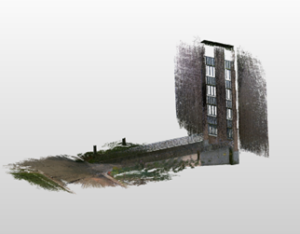
Point cloud capture of 701 Lake Hinsdale driveway after extraneous objects are removed from the scene.
Key Findings from NW Suburb CA
- Addresses Scanned: 4
- Purpose: Calculate the impact of drain width on stormwater drainage.
- Equipment Used: Leica BLK2Go handheld mobile LiDAR scanner.
Stormwater Collection Data:
- Drive 1: 1,109 SF; Discharge rate: 37.5 gpm.
- Drive 2: 1,509 SF; Discharge rate: 51.0 gpm.
- Drive 3: 1,608 SF; Discharge rate: 54.4 gpm.
- Drive 4: 1,527 SF; Discharge rate: 51.6 gpm.
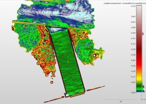
The drainage areas associated for the driveways were determined by analysing the elevation and surface slopes. Here, the calculated surface gradient maps the change of surface slope at the top of the 701 driveway between the driveway collection area and the gutter drainage.
The stormwater collection areas that drains to the 101 and 77 driveway trench drains are 1,509 SF at the 101 driveway and 1,109 SF at the 77 driveway as determined from the analysis of the LiDAR measurements.
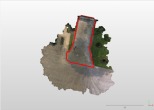
The stormwater collection area that drains to the 201 driveway trench drain is 1,607 SF as determined from the analysis of the LiDAR measurements.
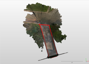
The stormwater collection area that drains to the 701 driveway trench drain is 1,527 SF as determined from the analysis of the LiDAR measurements.
What Does the Data Tell Us?
For northeast Illinois, the 100-year 1-hour rainfall event is defined at 3.25 inches/hr. Using LiDAR-measured areas and the formulated equations, a drainage system must be able to discharge approximately 55 gpm to meet this standard.
- Trench Requirements: Based on the analyzed data, the minimum trench width for effective drainage is roughly 3.25 inches.
- Discharge Drainpipe Requirements: To meet the requisite discharge rate, a 4-inch diameter pipe suffices with a 0.5% slope.
Recommendations
Considering the technical specifications of potential solutions, the ACO Drain PowerDrain® system, specifically the S100K model, meets the minimum requirements. This system offers a 4-inch diameter, 0.5% slope, and a discharge capacity of 108 gpm, making it suitable for the driveways inspected. However, it’s essential to ensure no blockages exist downstream, as this could compromise the system’s efficacy.
Conclusion
LiDAR technology is transforming how we approach drainage calculations, offering a level of precision and detail that traditional methods simply can’t match. For property managers of multi-family associations, it’s an invaluable tool ensuring their properties remain safe and efficient in even the heaviest rainfalls. As technology evolves, it’s crucial to harness these advancements to benefit our communities and ensure a better future.